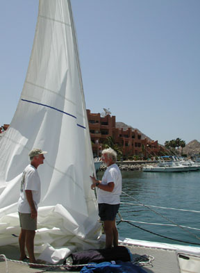
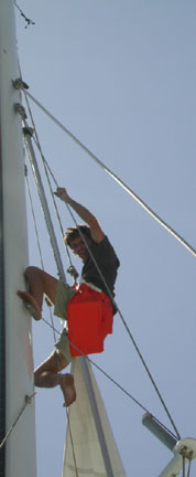
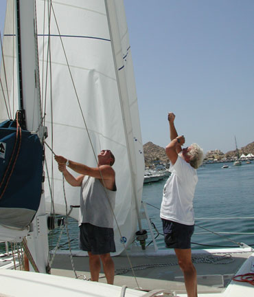
Hope springs eternal among sailors. Our only hope against this trip turning into a typical Bash is that another tropical depression--possibly one that follows Adolphs example and turns into another early hurricane--will develop in the Mexicos mid-coast, e.g. Acapulco area, that will generate winds from the south to push us forward. Meanwhile, we are preparing for harsh NW winds, just in case. Gunter and our new crew, Bix, John (Captain of Quest) and Jean Marie (Captain of Finally) replaced our jib with a storm sail this morning.
We had a long discussion with the port captain here, and since then I have received the weather faxes on the computer, checked the weather sites at the internet café twice a day, and listened to the various SSB nets each morning. For the local weather and rounding the Cape, I have been monitoring the weather patterns. Check the wind speed and direction here in the harbor, then add 10 to 15 knots to determine what youll find at the Cape, advised Tim Schaaf, the Port Captain. Any forecast is good for 24 hours or less and that does not cover local conditions. Get up at midnight, if you do not have significant wind then, go back to bed and set your alarm for 3:00AM. If it is still calm, take off at 4:00AM, or if you prefer, wait until dawn. That gives you plenty of time to round the Cape. If you do have wind in the early morning, sleep in because you wont be going out that day. So far our logbooks says: 6/4 0300 Wind 20K to 25K, WNW F6 6/5 0530 Wind gusting up to 20K, WNW 6/5 0800 Wind 16K, WNW F5 So were not going out this day. But were ready. The talk among the cruisers concerning the Baja Bash reminds us of the discussions preceding our sailing through the Papagayo region of Central America and the Sea of Tehuantepec after entering Mexico from the south. While youre waiting in port for a weather window, the talk tends to reach a fever pitch. This talk is never centers on the fortunate who lucked out and made the passage simply and easily. Where is the entertainment factor in that? The warnings from the Harbor Master covered every stretch of Baja: · Sail out around Cedros.
If you go in between Baja and the island and stop there, you may never
get out for weeks. Its like a wind tunnel there. Believe me, 80-foot
powerboats have tried to leave and have turned around. San Martin
is OK. Many cruisers in Puerto Vallarta had been frightened out of returning to California without a professional skipper. Some just turn over their boats while they fly back. Others sail their boats up the Sea of Cortez to La Paz, then have them trailered back to their home port. The experience of most of these cruisers, however, has been one of sailing the west coast of the United States-downwind, to the Mexican cruising grounds. Today, I looked up my diary entries about our crossing of the fearsome Gulf of Tehuantepec. April 21st. 5:30 AM The mauve-pink pastels of the pre-dawn mask the constellations of Orion
and the Big Dipper, leaving only the Venus and the dimming crescent
moon. I still see the red port lights of Finally and Makoko,
our buddy boats. A lone, majestic frigate bird swoops toward Pacific
Bliss, checking out our bare poles with the SSCA pennant and bright
Mexican flag on the spreaders, then glides away into the morning haze.
It is a 360° haze, encircling our little world of three. We have Force
4 winds, almost on the nose, but all is well with our world. The sun does not rise as a globe this morning. As it breaks through the haze, it creates bright sparkles that line the high cirrus clouds like jewels of the morning flashing their splendor, superior to any of the crowns of the richest queens on earth! As the day breaks, the three vessels turn off their navigation lights. The wind picks up. Gunter wakes up, and seeing that the other two yachts have just put up their sails, we quickly follow suit. The wind increases to Force 6, 18 knots. We are sailing close-hauled, waves crashing over the bow. It is a little lumpy right before breakfast. A VHF discussion ensues, and Pacific Bliss and Makoko decide to head directly to our waypoint # 8 to give us a better point of sail--more of a reach. There are always options in any sailing plan. Nothing is set in concrete. This keeps one always a little on the edge. Hug the shore, wind on the nose, and we motor uncomfortably all day, making poor headway. Cut across the last half of the bay, putting us about 12 miles from shore, and the warnings about the fearsome Tehuantepeckers echo in our ears. Hug the shore, they say, because then there will be no fetch. Keep one foot on the beach, dont take a chance. The words are drilled into me by now. The berm along the western two-thirds of the Gulf is level and regular, and when youre close in, it makes a good radar image. You can get right in close because the bottom is level and regular too. If youre overpowered by the wind, set a good storm anchor and ride it out, the guide says. Onboard barometers and observations cannot predict the approach of a Tehautepecker and the radio stations can only tell you that one is presently occuring, our guidebook continues. Running offshore could take you 500 miles offshore, another book states. I know a sailboat that tried to cut the Gulf and they ended up over 400 miles to sea and never were found, said a cruiser, just after we had sailed through Papagayo country. Enough already! We decide to enjoy a great sail. We sail at 9 to 10 knots under a full main and jib. This is where Pacific Bliss really shines! Makoko is now behind and at our port, I yell over the wind. They are heeled way over. I dont think that they can go any faster. After a few hours of this, the new talk on the VHF is that we are now making such good time that we may arrive at Hualtulco before dark, avoiding a second night at sea. What bliss! We did arrive that night in the marina, but after the sun had set, and that is yet another story! We were good guys crossing the Gulf of Papagayo. We hugged the shore all the way, just as we were told. We motored across in calm sea on a hot and sunny day with not the slightest hint of a breeze. Sunburned and weary, we arrived in El Coco to exit Costa Rica. There, at the immigrations desk, we met Jean Claude and Claudie of Makoko. What? You actually hugged the shore on the way? That takes hours! We cut. Ah, the daring French. Makoko became our buddy boat from then on. Papagayo country does not end at the Gulf named after these winds. Papagayos are gale-force winds that can be experienced all the way from Costa Rica to Quepos, Guatemala. They sometimes last 3 to 4 days and one has no choice but to hole up and let them pass. Like the winds that cause the misery called the Baja Bash, Papagayos also come from the north; they tend, however, to originate from northeast, traveling over the Central American landmasses from the Caribbean, rather than from the northwest. Makoko and Pacific Bliss were fortunate as we voyaged past Nicaragua to El Salvador and then on to Guatemala. We motored through most of Papagayo country, attempting to sail in light winds when we could. We found weather windows, and we took them-immediately. One afternoon we anchored in Bahia Elena, a beautiful bay, apparently protected on three sides. That night, we found out from the forecast that we had a window prior to another in a series of Papagayos. We pulled anchor at dawn, headed for El Salvador. Those unfortunates who stayed there were still there 4 days later. Now, with that, it is on to the Bash! |
|
|
|
|